


Cevennes-Leyris

soca
User
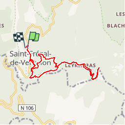

Length
9.5 km

Max alt
782 m

Uphill gradient
509 m
Km-Effort
16.2 km

Min alt
466 m

Downhill gradient
499 m
Boucle
Yes
Creation date :
2017-03-27 00:00:00.0
Updated on :
2017-03-27 00:00:00.0
3h26
Difficulty : Medium

FREE GPS app for hiking
 SityTrail
IGN / Geographical institutes
SityTrail Plus
The world is yours!
About
Trail Walking of 9.5 km to be discovered at Occitania, Lozère, Ventalon en Cévennes. This trail is proposed by soca.
Positioning
Country:
France
Region :
Occitania
Department/Province :
Lozère
Municipality :
Ventalon en Cévennes
Location:
Unknown
Start:(Dec)
Start:(UTM)
568148 ; 4904213 (31T) N.
Comments